

Seoul in History
The Capital city of Seou1, located on the downstream of the Han River that
runs across the central part of the Korean peninsula, has grown into a
metrornlis with a population of about 11 million or more than 22 percent
of the entire inhabitants of the Republic of Korea.
It is hard to determine when
a town was first founded at the site of today's Seoul. But archaeological
studies and finds indicate that men had begun to live in the Han River
basin encompassing Senul and its vicinity lnch'on, Puch'on, P'och'on, Yngju,
P'aju, Yongin and Kanghwa around 6000 years ago or 400O B.C. during the
prehistoric age.
At that time, people were
grouped in small tribal states, engaged chiefly in tillage using stone
too1s and earthenware. Relics found in the region include shell mounds,
dolmens.
These indicate that the dawn
of urban civilization had broken along the fertile Han River basin already
from the prehistoric age, though the founding of Seoul came late compared
with the ancient cities that had developed along the Nile in Egypt, the
Tigris-Euphrates in Mesopotamia, zmd Mohenjo-Daro and Harapa of Pakistzn.
The area of today's Seoul took
the form of town about 2000 years ago when it was chosen as the capital
of the Paekche Kngdom(18 B.C.-660 A.D.), one of the three ancient states
on the Korean peninsula. The town was then called Yiryesong. But, the name
was changed to Hanyang-gun after the Shilla Kngdom integrated the two other
states in 668 A.D., a name which was used to refer to the capital city
of later Choson Dynasty(1392-1910).
After the Koryo Dynasty(918-1392)
unified the peninsula again, the name of the area was changed to Yangju.
Initially it was a small provincial town, but afterwards developed to a
point where it was chosen as one of the "Three Small Capitals" and christened
Namkyong or Southern
Capital in 1067.
Seoul as Capital City
It was upon the founding of
the Choson Dynasty in 1392 that Seoul became the actual capital of Korea.
In an extensive search for a seat for his new capital on the prevalent
geomantic principles, the founding King, Yi Song-Gye, decided to build
his new capital in today's Seoul, finding the area fit for pople's living
and geographically ideal for rule by his new dynasty. Following a series
of preparatory works, the king moved his court to Hanyzng on October 28,
1394.
Palace buildings and royal shrines
were built, as were fortified walls surrounding the new capital. The 17
kilometer long walls were erected by a cumulative total of 197,003 workers
in 98 days. In the following year 1395, the King founded the Hansong Municipality
workers in charge of the administration and public security of the capital
zone. The admiinistrative area of the capital consisted of five inner-wall
zones of East, West, South, North and the Central with outer zone 4 kilometers
of the wall. The function of these zones was comparable to that of today's
wards,
Historical records show that
the population of Senul stood at 103,328 inside the wall and approximately
110,O00 including those outside in 1428, the tenth year of the reign of
Kng Sejong, the fourth monarch of Choson. Given the usable area of kmd
inside the walls, the population density was quite high.
Canals were dug for use as sewers.
All the land of the capital was owned exclusively by the State.
For about 200 years from the
1660's, the poplation of Seoul remained in the neighborhood of 200,000.
Toward the end of the 19th century, however, the population began to inch
up, influenced by the owning of the nation to foreign powers. Foreign missions
started to own offices in Seoul giving the city its first cosmopo1itan
touches. Following the annexation of Korea by Japan in 1910, Seoul was
renamed Kyongsong. In 1936, its population stood at 730,000.
With national liberation on
August 15, 1945, the city was given the official name of Seoul, by which
it had long been known, as the wor"Seoul"
means "Capital". In 1946, Seoul
was upgraded to the status of a special city placed diredly under the control
of the central goverrment. The jurisdictional area of the capital was expanded
to 269.73 square kilometers in 1949 when the city had nine Gus(Wards) and
a population of about 1,400,000.
The burgeoning capital city,
however, was reduced to piles of debris during the Korean war that broke
out on June 25, 1950 and raged no fewer than three years. The signing of
the Armistice Agreement saw Seoul regain the function of national capital.
Rehabilitation had begun promptly to rebuild it into a modern metropolis.
Under a spcial legislative measure efferted in 1962, the Seoul Metropolitan
Govemment was made subject to the direct control of the Prime Minister,
enabling Seoul to develop into an auton-omous administration, sepzuated
from the supervision of the central govemment. The administrative area
of the capital city was again expanded to 593.75 square kilometers in January
1963, and further to 605.30 square kilometers in March 1973.
The development of the Southern
part of Seoul, South of the Han River, has been extensively made in order
to meet the increasing various demands for urban administration in the
1970's. By succesfully hosting the Asian Games in 1986 and Olympiad in
1988, Seoul has made great strides toward the goal to be ranked among the
most advanced capital cities in the world. By introducing local self-govemment
rule in 1991, Seoul city Govemment has laid the foundation for the self-administration
by the citizens of Seoul. The year of 1994 was the 600th year since Seoul
was decided to be the capital of Korea.
Today's Seoul became a metropolitan
city with the population of about 11 millions and the size of about 605.58
square kilometers. And it comprises 25 Gus and 530 Dongs as administrative
division. While maintaining and restructuring the city which has bcm greatly
expanded in the process of urbanization with the economic development of
Korea for the last 30 years, the city of Seoul continues to grow into a
more comfortable city to live in with clean environment.
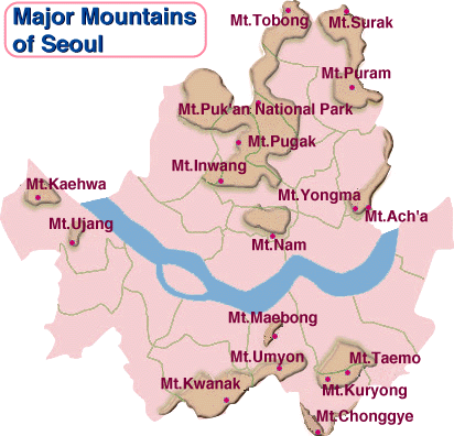 The central district of Seoul is surrounded by the four inner mountains,
the highest among them being Mt. Pugak (342m), a spur extending south from
Mt. Puk'an. Mt. Pugak rises high above Kyongbok-kung (palace), the main
royal palace of the Chosun Dynasty.
The central district of Seoul is surrounded by the four inner mountains,
the highest among them being Mt. Pugak (342m), a spur extending south from
Mt. Puk'an. Mt. Pugak rises high above Kyongbok-kung (palace), the main
royal palace of the Chosun Dynasty.
Mt. Inwang (338m) is made of
granite and has Mt. An (295m) to the southwest. Mt. Nam (262m), originally
called "Mokmyok-san", now sits in the center of Seoul as the most beloved
and frequented mountain by citizens and foreign tourists. Mt. Nak (111m),
the lowest among the four inner mountains, is also called "Nakta-san" (meaning
camel mountain) because of its hump-like shape. Located in chongno-ku,
downtown Seoul, it has lost its stature as a mountain to the extent that
its peak is now covered with houses and buildings.
Mt. Puk'an National Park in
the north of Seoul is comprised of two major park areas of Mt. Tobong and
Mt. Puk'an with Uiryong Ridge as a borderline in between. Mt. Puk'an is
also referred to as "Samgak-san" (meaning triangular mountain) because
of its three distinctive peaks of Paegun-dae, Insu-bong, and Mangyong-dae.
Paegun-dae (837m) is the highest peak in Seoul's vicinity, and the waters
of the port city of Inch'on can be seen from its top on clear days. Mt.
Puk'an has as many as twenty high peaks including Paekun-dae, and boasts
a beautiful lanscape and an excellent view overlooking 10 or so valleys
such as Ui Valley. There is also the Mt. Puk'an Fortress Wall with several
gatehouses such as Taenammun, which was constructed in the 37th year of
King Sukch'ong (1711).
Mt. Tobongconsists of many peaks
such as Chaun-bong (740m ; 'bong' means peak), the highest among them,
Manjang-bong and Sonin-bong. It is made of granite and offers a variety
of magnificent rock formations. Mt. Puk'an and Mt. Tobong were announced
as national parks on April 2, 1983, and have since been frequented by 15
million residents in and around the capital area for relaxation or nature
study.
Mt. Kwanak (629m) in the south
of Seoul is made up of very rugged rocks. Yonju-dae is the highest peak
forming a chain of ridges together with Samsong-san and Changgun-bong.
Mt. Kwanak is bordered by Anyang City to the south, and Kwach'on City with
the Government Office Complex to the southeast. To the east is Namtae-ryong
pass, which connects Kwach'on with Mt. Umyon, and Seoul National University
is to the north of the mountain.
(638m) and Mt. Puram (508m) in
the northeastern part of Seoul share boundaries with Uijongbu City and
Namyangju City. Both mountains are made of granite and have cliffs and
precipices which project a picturesque scenery together with deep valleys
below. Other mountains such asMt. Yongma (348m) and Mt. Acha (285m) in
the east, Mt. Taemo (293m) and Mt. Kuryong (238m) in the southeast, and
Mt. Umyon (293m) on the southern boundaries of Seoul also provide good
places for people to relax in nature.
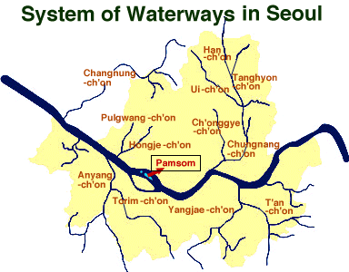
The City of Seoul is situated
on the lower reaches of the Han River which flows through the central part
of the Korean peninsula. The Han
River, the fourth longest in Korea
only after the Amnok (Yalu), Tuman (Tumen), and Nakdong Rivers, is 497,5
km long. Abundant in water sources, it accounts for about a third of the
water supply for both households and industries in the capital area. Rivers
in Seoul are comprised mainly of the Han River flowing from east to west
and many tributaries flowing into the Han River. Major tributaries include
Ch'onggye-ch'on ('ch'on' means stream), Chungnang-ch'on and Moraenae to
the north of the Han River; and Songnae-ch'on, Tan-ch'on, and Anyang-ch'on
to the south of the Han River.