|
PAPER 2000 Year |
||
|
|
Evaluation of Urban Landscape Problem Using Analytic Hierarchy Process Method
ABSTRACT This paper describes the application of analytic hierarchy process to evaluate the multicriteria Urban Landscape Problem, in Pusan, Korea. The study utilizes structured pair wise comparison of analytic hierarchy process to reach a scale of importance from the landscape elements when estimate the urban landscape problem. In this study, both AHP method and visible analysis using computer graphics were applied to synthesize an index of Urban Landscape Problem in all area. The results of the case study indicate the potential utility of the tool for assessing the urban landscape problem at a local level, identify problem locations, and specify the possible causes of those problems. In addition, in order to preserve the urban landscape from urban planning or developments in the future, it is important to evaluate the potential problem of urban landscape by quantitative analysis and decision support tool.
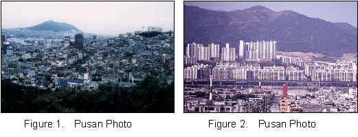
1. INTRODUCTION People who live or perform their activities adjacent to place in urban areas have often recognized as undesirable phenomena, amenity degradation and adverse environmental impacts caused by urban landscape problems. These people are gradually becoming more aware of these effects. The urban landscape problems include destruction of natural resource, visual obstruction by height of building and location of high-rise building and lack of landscape master plan. Although a few urban landscape problems can possibly be quantified, most of urban landscape problems can only be qualitatively evaluated. In addition, urban landscape was composed of various landscape elements and the urban planning regulation. The estimation and assessment of urban landscape problems are therefore difficult and complicated. Then, we decide to apply both the AHP method and visible analysis to estimate the urban landscape problems. We clarify the problem of an urban landscape that captures the estimate standards and the visual situation of the area, where these landscapes exist. In the case study, in order to decide whether the landscape problem of each area is high or low, we used the AHP method and visibility analysis conscious construction of expert on the landscape. Pusan, the biggest international port city in Korea, lies on the southeast coast of the Korean peninsula. Pusan has abundant waterside landscape as a port city, and an urban landscape with many sloping areas since the urban area is surrounded by hill and mountain. In the last few years, the management problems of urban landscapes have become an important factor in urban planning policy in Korea. Due to rapid urbanization and the designation of development restriction districts, a dense and high-rising urban space has been produced in Korea cities. There is increasing interest in the preservation to the quality urban landscape and will be tried a new landscape control policy that is suitable to the circumstances of Korea. In order to make effective landscape control regulations, which maintain the original landscape, at first it is important to grasp the index of the urban landscape problem. Figure 1 and figure 2 show that the present situation of Urban landscape in Pusan city.
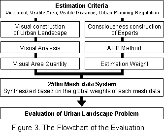
2. PURPOSE AND METHOD OF ANALYSIS The main purpose of this paper is to develop an evaluation method of urban landscape problem using AHP method and visible analysis using computer graphics. The first step, we set 4 estimation criteria of urban landscape problem. The following items were examined for evaluating the urban landscape problem; 1) Viewpoint, 2) Visible Area, 3) Visible Distance, 4) Urban Planning Regulation. The second step, this study is to propose the method for visual evaluation of landscape estimation elements by calculating the value of "Visible Area Quantity". The third step, we construct the Hierarchical Structure and conduct a questionnaire on 24 experts and calculate a weight of urban landscape problem. And, we apply this method to the Pusan, Korea. As a result, the landscape condition of problematic area is visualized, and the evaluation method enabled to identify the valuable areas for visualized. As a case study, mesh-data of Pusan City in KOREA was used with an area of 849.79km2
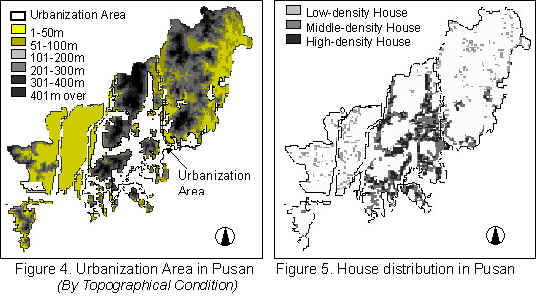
3. VISIBLE ANALYSIS METHOD We quantitatively and numerically analyze the physical landscape identity in virtual three-dimensional space using computer. We obtained the visible range using the topographical data and the distribution data of landscape decision elements. The topographical data and the distribution data were obtained using "Mesh data-system". The mesh size of these data is about 250m. The distribution data, for which we also used the "Mesh data-system", was derived from the topographical map, the land use map, and the field survey. We set the viewpoint and view-object, the viewpoint is all land meshes (11331meshes) containing the Pusan City and the view-object is all mesh including sea mesh inside of 5,000m. From this result we were able to determine the arrangement of the landscape decision elements visible condition from each mesh. In figure 4 (shows the urbanization area includes housing district, commercial district, industrial district and the green area includes green district, development restriction district in a mesh) and figure 5(shows house distribution by density), it can be seen that urbanization area are developed to high level altitude area. In the mountain near urbanization area, it has gradually covered by densely built dwelling houses and high-rise buildings.
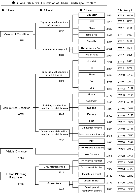
4. EXTRACTION OF JUDGE SCALE USING AHP METHOD We has been using AHP as part of a methodology for the Urban Landscape Problem Evaluation of urban planning projects such as high-rise building control, classification and selection of projects in a landscape improvement plan, etc. A hierarchical structure is established by composing the complex problem into a hierarchy of interrelated decision elements. The global objective (Estimation of Urban Landscape Problem) is placed at the top of the hierarchical structure. And we set 4 Criteria (example: viewpoint, visible area, visible distance, urban planning regulation). The lowest level of hierarchy structure consists of more detailed elements (urban landscape problem decision element, for example: mountain, hill, plane, river and sea etc.), which interrelate to the parent elements (Estimation Criteria) in the next higher level. Typically, the alternatives are contained in lowest level of the hierarchy. Figure 6 shows the Hierarchy Structure and relative weight global weight on each element. We conduct a questionnaire on 24 experts about urban landscape problem and calculated a global weight of each decision element.
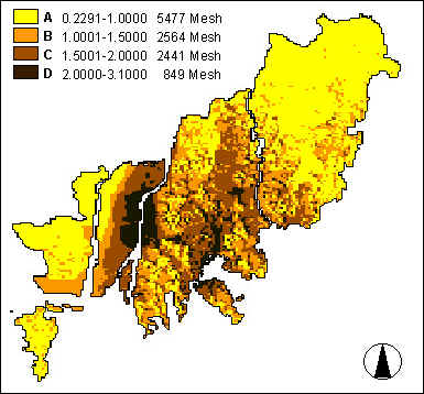
5. EVALUATION OF URBAN LANDSCAPE PROBLEM 1) Calculation of Urban Landscape Problem Score We calculated urban landscape problem score that is synthesized both the total weights of each mesh data was correspondingly computed. And the landscape problem condition in the whole area is visualized. Due to this method, we could find the quantitative value of urban landscape problem area clearly. This formula is explained the Urban Landscape Problem Score calculation method of one mesh. 2) Ranking of Urban Landscape Problem Score We calculated the urban landscape problem score each mesh-data. By this calculation, we could get the distribution of the urban landscape problem score by each mesh-data shown figure 7. Rank A (0.1000 below): The low scored meshes are distributed the plain area, mountain in development restriction district or green district which have settled the viewpoints. Rank B (0.1001-1.5000): The scored meshes are distributed the residential district, green district which have settled the viewpoints. Rank C (0.1501-2.0000): The scored meshes are distributed the residential district, commercial district, industrial district which have settled the viewpoints. Rank D (0.2000 over): The high scored meshes are distributed the plain area around the Nak-Dong River, the center area near seacoast, the hilly region close to town which have settled the viewpoints. The problematic elements are apartment, building in visual area. Figure 7. Ranking of Urban Landscape Problem Score
6. CONCLUSION This paper described the quantitative evaluation method of visible analysis and application of a decision making tool for evaluating the urban landscape problem, Pusan, Korea. The result is an integration of Analytic Hierarchy Process (AHP) and visible analysis using mesh-data system. We developed the program evaluating the visible condition of problematic landscape quantitatively. Furthermore, both methods were applied synthesis mesh-data phase to derive global value of urban landscape problem on all area. Finally, the visible condition of problematic landscape seen from the whole urban area is visualized. The results of case study indicate the potential utility of the tool for assessing the value of urban landscape problem at a local level, identify problem locations, and specify the possible causes of these problems. In addition, this evaluation method can be applied to any city and will enable the identification of problematic areas for preservation.
REFERENCES Kyunghee KIM, S. SATO, T. ARIMA, N. HSIAO, and S. KIM, Evaluation of the Urban Landscape in Pusan by multivariate analysis, Seventh International Conference on Computing in Civil Building Engineering, Seoul, KOREA, pp.759-764, 1997 T. Edamura, T. Tsuchida, An Urban Environment Improvement Project Planning Support System, Proc. 5th Int. Conf. on Computers in Urban Planning and Urban Management, Vol. 2,pp.632-643, 1997 P. Klungboonkrong and M. A. P. Taylor, Application of Analytic Hierarchy Process and Fussy Set Theory in Multicriteria Environmental Sensitivity Evaluation of the Urban Road Network, Proc. 5th Int. Conf. on Computers in Urban Planning and Urban Management, Vol. 2,pp.771-781, 1997 Saaty, T. L. The Analytic Hierarchy Process: Planning, Priority Setting, Resource Allocation, McGraw-Hill International Book Company Saaty, T. L. Group Decision Making and the AHP, in B. L. Golden, E. A. Wasil and P. T. Harker, The Analytic Hierarchy Process: Applications and Studies, Springer-Verlag. KEYWORD Urban landscape problem, AHP method, Visible analysis, Mesh-data system
|